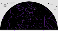
Last November, as another semester of teaching Elementary Astronomy drew to a close, I finally broke down and started writing my own planetarium simulation.
On its face, this was a ridiculous waste of time. There are already dozens, if not hundreds, of planetarium simulation programs that will show you where the stars and planets appear in the sky, as viewed from your chosen location at your chosen time. They run on every microcomputer platform and many handheld devices. Some are extremely sophisticated, with databases of millions of stars, beautiful images, and even the ability to interface with a telescope.
But I wanted something a little different. To be useful to most of my students, a simulation program has to be (a) free; (b) delivered through a web browser, with nothing to download or install; (c) easy for beginners to understand; and (d) convenient for showing the motions of the stars and other objects with respect to earth's horizon.
Sky View Cafe is a great Java applet that almost fits the bill, and I’ve been recommending it to my students for several years. It’s loaded with features and was obviously written by a pro. But its time/date control is a bit awkward to use, so it isn’t ideal for showing celestial motions. Worse, its default full-sky view can be disorienting for beginners, who often have trouble relating the circle on the screen to the domed sky overhead.

Fifty-six years ago, H. A. Rey showed the best way to draw the sky for beginning observers. The illustrations in his delightful book Find the Constellations show half the visible sky at a time, as if viewed through a huge domed window stretching 180 degrees from side to side, from the horizon at the bottom to zenith at the top. I vividly remember reading that book as a child, and I wanted a web applet that gives a similar view of the sky.
I also wanted intuitive, analog controls for changing the time and date, so the sky’s motions would be easy to explore. Inspired by the GoSkyWatch iPhone app, I settled on a circular dial for changing the time of day, with a concentric inner dial for changing the date of the year. I added similar analog controls for setting the latitude and longitude.

To make the motions even more apparent, I included a feature that WSU’s digital planetarium projector has: the ability to show “trails” that simulate long-exposure or multiple-exposure photographs. Besides the familiar star trails, you can use this feature to trace out analemmas and retrograde loops.
This project has soaked up much of my free time for the last three months, but I think it’s essentially finished for the time being. I hope my students--and others who discover it--will find it useful.


